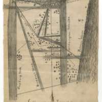
Segregated School Districts, Jefferson Township School Census Map
Dublin Core
Title
Segregated School Districts, Jefferson Township School Census Map
Subject
African Americans, education, race relations
Description
Virginia's public school system required racial segregation. In drawing up districts for Alexandria County (later Arlington County), the mapmaker drew what looks like a badly gerrymandered voting district with each dwelling designated as W ("white") or C ("colored"). Jefferson Township was located near what is now Crystal City and the 14th Street Bridge connecting Virginia and the District of Columbia.
Source
Alexandria County Superintendent of Schools Records, 1851-1920, Alexandria/Arlington County Court Records, Local Government Records Collection, Library of Virginia.
Date
1870
Contributor
Library of Virginia
Rights
CC BY-SA
Relation
Finding Aid to Alexandria County Superintendent of Schools Records.
Format
JPG
Type
Manuscript drawing
Identifier
11_0080_001 Segregated districts Plat
Coverage
Alexandria, Virginia
Citation
“Segregated School Districts, Jefferson Township School Census Map,” Remaking Virginia: Transformation Through Emancipation, accessed December 16, 2025, https://virginiamemory.com/online-exhibitions/items/show/571.
