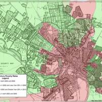
Current Poverty Areas Compared to 1937 HOLC Map of Red Lined Neighborhoods, 2010.
Dublin Core
Title
Current Poverty Areas Compared to 1937 HOLC Map of Red Lined Neighborhoods, 2010.
Description
This overlay shows 2010 poverty data on the old 1937 HOLC map that red lined black neighborhoods.
Creator
Courtesy John Moeser
Source
Early 20th cen. Poverty Compared to Current Poverty, 2010. Courtesy John Moeser, Bonner Center for Civic Engagement, University of Richmond.
Publisher
Bonner Center for Civic Engagement, University of Richmond.
Date
2010
Coverage
Still Image Item Type Metadata
Original Format
Map
Collection
Citation
Courtesy John Moeser, “Current Poverty Areas Compared to 1937 HOLC Map of Red Lined Neighborhoods, 2010.,” Online Exhibitions, accessed December 3, 2025, https://virginiamemory.com/online-exhibitions/items/show/28.

