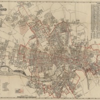
Wagner's Complete Map of Richmond, A.C. Wagner, 1927
Dublin Core
Title
Wagner's Complete Map of Richmond, A.C. Wagner, 1927
Description
Includes street index, electric car lines and bus routes. Includes surrounding streets in Henrico and Chesterfield Counties. Shows Richmond city limits, streets, railroads, interurban lines and ward boundaries. Scale [ca. 1:20,000].
Creator
A.C. Wagner Company
Source
A.C. Wagner, "Wagner’s Complete Map of Richmond." Cincinnati : A.C. Wagner Co., c. 1927. Library of Virginia, Map Collection.
Date
1927
Relation
G3884.R5 1927 .A3
Photo # 14-0977-001
Photo # 14-0977-001
Coverage
Still Image Item Type Metadata
Original Format
Map
Collection
Citation
A.C. Wagner Company, “Wagner's Complete Map of Richmond, A.C. Wagner, 1927,” Online Exhibitions, accessed December 3, 2025, https://virginiamemory.com/online-exhibitions/items/show/13.

